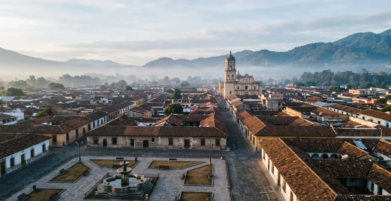
La Laguna’s enduring legacy lies not in its beauty, but in its role as the first unfortified colonial city—a real-world urban laboratory for Renaissance philosophical and scientific principles.
- It deliberately broke from military norms by being built inland, prioritising an intellectual and administrative vision over coastal defence.
- Its grid plan was a direct application of navigational science, creating a living blueprint later exported to hundreds of cities in the Americas.
Recommendation: To truly experience La Laguna, one must read its streets as a historical text, deciphering the layers of intellectual, religious, and secular power embedded in its very layout.
San Cristóbal de La Laguna often appears on travel itineraries as a colourful, charming colonial town—a picturesque day trip on the island of Tenerife. Visitors wander its grid-like streets, admire ornate wooden balconies, and photograph pastel-coloured facades. While these observations are true, they only scratch the surface of a much deeper reality. To see La Laguna merely as pretty is to miss the revolutionary ideas encoded within its very stones.
Most guides point to its status as a UNESCO World Heritage site and its influence on Latin American city planning. But they rarely explain the profound intellectual shift the city represents. This was no accident of history; it was a deliberate, radical experiment. It was the first time a colonial city was designed not for war, but for peace; not for defence, but for civil administration and the cultivation of knowledge. It was, in essence, a philosophical statement made manifest in urban form.
This article moves beyond the typical tourist narrative. We will adopt the perspective of a historian to understand the city as a living document. We will explore how its defiant inland location set the stage for its intellectual destiny. We’ll examine the dual axes of religious and secular power etched into its map, unpack the scientific and philosophical principles behind its famous grid, and see how this 500-year-old urban laboratory continues to foster a unique culture, from its hallowed library archives to its vibrant student nightlife. This is the story of how an idea, born of the Renaissance, created the intellectual capital of the Canaries.
This guide delves into the historical and cultural framework that defines La Laguna. The following sections are structured to reveal the city’s unique character, from its foundational principles to its modern-day life, providing a comprehensive overview for the intellectually curious visitor.
Summary: Why La Laguna is a Living Model of Renaissance Thought
- Why Locating the Capital Inland Defied Spanish Colonial Coastal Defence Norms
- How to Access University Historic Library Collections and Archive Exhibitions
- Religious Power vs Secular Government: What La Laguna’s Layout Reveals About Colonial Hierarchy?
- How to Experience Student Quarter Nightlife Blending Tradition With Contemporary Culture
- The Pedestrianisation Conflict Threatening UNESCO Status in 45% of Heritage Streets
- Why Unfortified Colonial Grids Influenced Latin American City Planning for 300 Years
- Why Only 6 Atlantic Laurel Forests Met UNESCO’s Strict Universality Criteria
- Why La Laguna Streets Follow 15th-Century Grid Planning Models
Why Locating the Capital Inland Defied Spanish Colonial Coastal Defence Norms
The standard model of Spanish colonial expansion in the 15th and 16th centuries was brutally pragmatic: establish a fortified port, control the sea lanes, and defend against pirates and rival powers. Yet, when Alonso Fernández de Lugo founded San Cristóbal de La Laguna in 1496, he chose a site in the fertile Aguere valley, miles inland. This decision was a radical departure from strategic norms. It signalled an intent to create not just a military outpost, but a stable, permanent civic and administrative centre for the entire archipelago.
By turning its back on the coast, La Laguna prioritised agriculture, governance, and intellectual life over maritime defence. This allowed for the development of an open, unfortified city plan—a concept so unusual for its time that it became a defining feature. This choice established it as the administrative, religious, and intellectual heart of the Canary Islands for over two centuries. Though its official status as sole capital would eventually be challenged, its foundational character was set. The city’s capital status was formally transferred to the coastal port of Santa Cruz in 1723, a move driven by burgeoning maritime trade, yet La Laguna’s cultural and academic primacy remained undisputed.
This unique conception is central to its universal value. The UNESCO World Heritage Committee itself highlights this distinction, noting it as “the first example of an unfortified town laid out and built according to a complete plan based on navigation, the science of the time.” The location was not a defensive weakness but a philosophical strength, allowing a new kind of city—an urban laboratory for civil society—to flourish away from the constant threat of coastal raids.
How to Access University Historic Library Collections and Archive Exhibitions
La Laguna’s role as an intellectual capital is not just a historical title; it is a living reality housed within the hallowed halls of its university. The University of La Laguna, with academic traditions dating back to 1792, is the custodian of the city’s scholarly soul. For the heritage tourist, accessing its historic collections offers a direct connection to this 500-year legacy of learning. The main repository of this knowledge is the university’s Biblioteca General y de Humanidades.
While the main library serves the contemporary student body, its true treasure for the historian is the ‘Fondo Antiguo’ (Old Collection). Accessing these rare books and manuscripts typically requires a legitimate research purpose and a formal application. Visitors should contact the library administration well in advance, stating their academic credentials and research interests. However, the university frequently makes its heritage accessible through public exhibitions. These are often held in the main library building or other historic university properties and showcase thematic selections from the archives. Check the official University of La Laguna (ULL) website for a calendar of events and exhibitions before your visit.
This paragraph introduces the tangible aspect of La Laguna’s intellectual heritage. To better appreciate the texture and atmosphere of these archives, the following image captures the essence of the ‘Fondo Antiguo’.
As this image conveys, the experience is tactile and immersive. Beyond formal collections, many of the city’s former convents and palaces, now part of the university, also contain smaller historical archives or host related cultural events. Engaging with these spaces provides a more complete picture of how knowledge has been curated, preserved, and disseminated in the city for centuries.
Religious Power vs Secular Government: What La Laguna’s Layout Reveals About Colonial Hierarchy?
To walk through La Laguna is to read a map of colonial power. The city’s original layout is a masterclass in social and political engineering, deliberately separating the realms of authority into two distinct but interconnected zones. This “intellectual topography” reveals the deep-seated hierarchy of the 16th century. The city was fundamentally a dual-poled entity: the Villa de Arriba (Upper Town) and the Villa de Abajo (Lower Town). The Villa de Arriba was the heart of civic and commercial life. Centred on the Plaza del Adelantado, it housed the seat of government (the Cabildo), the marketplace, and the grand homes of the conquering nobility and wealthy merchants.
In contrast, the Villa de Abajo was the domain of ecclesiastical power. This district grew around what would become the Cathedral and the Bishop’s Palace, surrounded by convents and monasteries. The physical separation was intentional, creating a city with two centres of gravity. This layout wasn’t just a practical arrangement; it was a spatial representation of the two pillars of Spanish colonial rule: the Crown and the Cross. The remarkable state of preservation, with over 600 historic Mudejar-style buildings still standing, means this dualism is not just a historical footnote but a legible feature of the contemporary city.
The incredible fidelity of the modern city to its original design is confirmed by historical records. The original 15th-century layout, a testament to master planner Leonardo Torriani, remains almost entirely intact. Walking from the stately, business-like Plaza del Adelantado to the spiritual atmosphere around the cathedral, one can still feel the shift in tone and purpose, experiencing the colonial hierarchy firsthand through the urban landscape.
Action Plan: Reading the Colonial Power Dynamics in La Laguna’s Streets
- Points of contact: Identify the key buildings of religious power (Cathedral, convents) versus secular power (Town Hall, Casa de los Capitanes Generales).
- Collecte: Photograph the distinct coats of arms on noble palaces and contrast them with the religious iconography on ecclesiastical buildings.
- Cohérence: Compare the relative austerity of some convent walls with the opulent ornamentation of merchant family homes.
- Mémorabilité: Note the difference in scale and atmosphere between the Plaza del Adelantado (the centre of government) and the quieter plaza around the cathedral.
- Plan d’intégration: Design a walking tour that starts in one “power zone” and crosses into the other, consciously observing the changes in architecture and streetscape.
How to Experience Student Quarter Nightlife Blending Tradition With Contemporary Culture
La Laguna’s intellectual character is not confined to dusty archives; it spills out into the streets every evening, powered by a vibrant student population. The university town is home to some 25,000 students, a demographic that infuses the historic city with a youthful energy unique in Tenerife. This creates a fascinating blend where centuries-old traditions meet contemporary nightlife, offering an experience far removed from the island’s tourist resorts.
The epicentre of this energy is a district known as “El Cuadrilátero” (The Quadrilateral). As the name suggests, it is a compact grid of alleyways packed with an astonishing density of over 100 bars, tapas restaurants, and small clubs. Here, you’ll find modern cocktail bars sitting alongside traditional “tascas” that have served students for generations. The atmosphere is authentically local, driven by conversation, music, and the social ritual of the “tapeo” (hopping from bar to bar for tapas).
This image captures the spirit of ‘La Noche Lagunera’, where tradition is not just remembered but actively performed.
Perhaps the most enchanting expression of this blend is the presence of the “Tunas.” These are traditional student music groups, dressed in medieval attire, who wander the plazas and alleyways performing folk songs on guitars and mandolins. Witnessing a Tuna performance on a cool evening in the Plaza de la Concepción is to see La Laguna’s history come alive, a direct link to the troubadour traditions of Europe’s oldest universities, enacted by the students of today.
The Pedestrianisation Conflict Threatening UNESCO Status in 45% of Heritage Streets
A city preserved in amber also faces the pressures of the modern world. La Laguna’s “outstanding universal value,” as described by UNESCO, lies in its pristine 15th-century plan. However, the 21st-century challenge of managing traffic, commerce, and quality of life has led to a contentious process of pedestrianisation. While creating car-free zones is often seen as a positive step for historic centres, in La Laguna, the scale and execution of this policy have sparked debate about whether it enhances or endangers the city’s heritage.
Since 2022, the Town Hall has intensified the process under the Special Protection Plan (PEPCHLL), transforming key streets like Alcalde Suárez Melián and Juan de Vera into pedestrian-only zones. These reurbanisation projects are significant undertakings, with costs exceeding two million euros in some areas. The goal is to improve the experience for residents and visitors, reduce pollution, and boost local businesses. However, critics argue that the modern paving materials, street furniture, and standardised designs can erase subtle historical textures and disrupt the original “town-territory” concept.
The conflict lies in a fundamental question: how do you adapt a city designed for foot soldiers and horse-drawn carts to the needs of the 21st century without undermining the very authenticity that makes it special? With nearly half of the historic streets affected by these plans, the debate is not just academic. It is a live negotiation between heritage preservation and urban evolution, with the city’s coveted UNESCO status hanging in the balance, a reminder that a living city cannot be a museum.
Why Unfortified Colonial Grids Influenced Latin American City Planning for 300 Years
La Laguna’s significance extends far beyond the Canary Islands. It stands as the original blueprint, the “mother city” for hundreds of colonial towns across the Americas. While cities like Havana, Santo Domingo, and Cartagena are more famous, few know that La Laguna is actually the model for their iconic grid layouts. It was here, in this Atlantic urban laboratory, that Spain tested and perfected the urban planning model it would export across an empire for the next three centuries.
The key innovation was its status as a “unique example of a non-fortified, colonial town.” Unlike the heavily fortified ports designed to repel attacks, La Laguna was conceived in peace. This allowed for an open, rational, and human-scaled grid that prioritised civic life, commerce, and easy movement. The streets were laid out “a cordel y regla” (with rope and ruler), reflecting a new Renaissance obsession with order, mathematics, and philosophical harmony. This was not the chaotic, organic growth of medieval European cities; this was a preconceived ideal imposed upon a new territory.
When the conquistadors arrived in the Americas, they carried this mental template with them. Faced with the task of building new cities from scratch, they replicated the model they knew: a central plaza (Plaza de Armas), a grid of straight streets, and designated zones for church and government. This modular, scalable, and easily reproducible design was perfectly suited to the rapid colonisation of a vast continent. From Lima to Mexico City, the DNA of La Laguna’s unfortified, peace-time grid can be seen, making a stroll through its streets a journey back to the very genesis of Latin American urbanism.
Why Only 6 Atlantic Laurel Forests Met UNESCO’s Strict Universality Criteria
La Laguna’s intellectual sphere was not limited to its city walls. The island of Tenerife itself became a subject of intense scientific inquiry, and the city served as the base for some of history’s greatest naturalists. The nearby Anaga and Teno mountains contain pristine remnants of laurisilva, or laurel forest, a type of subtropical cloud forest that is a living relic of the Tertiary Period. This natural heritage is as valuable and rare as the city’s urban design, and its study is intrinsically linked to La Laguna’s intellectual history.
The most famous intellectual drawn to this natural laboratory was Alexander von Humboldt. During his pivotal visit in 1799, en route to his groundbreaking exploration of the Americas, he used his time in Tenerife to produce the first scientific description of the island’s distinct plant elevation zones. His work on the “Naturgemälde,” a unified vision of nature, was profoundly shaped by what he saw on the slopes of Mount Teide. Decades later, a young Charles Darwin, inspired by Humboldt’s writings, was desperate to explore Tenerife’s unique ecology when the Beagle arrived offshore in 1832. These forests became a touchstone for the developing theories of biogeography and evolution.
Humboldt’s connection to the island was deeply personal, reflecting the profound impact of this natural world on a great mind. His sentiment captures the magnetic pull of the island’s unique environment:
I’m leaving almost with tears in my eyes; I would like to come and live here
– Alexander von Humboldt, Personal letter, June 1799
Today, areas like Garajonay National Park on La Gomera (a sister Canary Island) are recognized by UNESCO for this very laurel forest ecosystem. The strict criteria for “outstanding universal value” mean that only the most pristine and significant examples are inscribed, highlighting the rarity of the natural world that so inspired these pioneering scientists, whose intellectual base was the city of La Laguna.
Key Takeaways
- La Laguna’s inland, unfortified design was a radical choice prioritising a civil and intellectual ideal over military strategy.
- The city’s grid is more than a layout; it’s a “philosophical grid” reflecting Renaissance science and order, which became a template for the New World.
- The tension between religious and secular power, still visible in the urban fabric, is central to understanding its 500-year history.
Why La Laguna Streets Follow 15th-Century Grid Planning Models
At its heart, the design of La Laguna is a triumph of Renaissance thought. The city’s adherence to a grid model was not an aesthetic choice but a deep-seated philosophical one. In the late 15th century, European thinkers were rediscovering classical ideals of order, harmony, and rationality. The chaotic, walled, and unsanitary medieval city was seen as a relic of a dark past. The future belonged to the “ideal city”—a place of logic, light, and mathematical precision.
La Laguna became the first real-world canvas for these ideas. Its plan was a direct application of the most advanced knowledge of the era. As the World Heritage Committee noted, the plan was born from a complex vision rooted in science and philosophy.
It was drawn from a complex project, based on philosophical principles, carried out thanks to the knowledge of navigation, the science of its time.
– World Heritage Committee, Turismo de La Laguna
This paragraph introduces the foundational concept behind La Laguna’s layout. The minimalist aerial view below illustrates the purity and precision of this “philosophical grid” as it is etched into the landscape.
The “science of its time” was maritime navigation. The same tools used to plot courses across uncharted oceans—the compass, the astrolabe, the ruler, and geometric principles—were used to lay out the city’s streets. This created a city that was not only orderly but also fundamentally open and peaceful. Without the need for defensive walls, there were no winding alleys or dead ends. Instead, the grid created a permeable, legible urban space that promoted commerce, social interaction, and a sense of civic order, a true living blueprint of a new, more enlightened age.
To visit La Laguna is to do more than sightsee; it is to engage in an act of historical discovery. By learning to read the city’s streets, to understand the forces that shaped its unique design, and to appreciate its role as a global blueprint, the visitor transforms from a mere tourist into a historical explorer. The next logical step is to walk these streets yourself, armed with this knowledge, and decipher the layers of meaning in this remarkable urban laboratory.