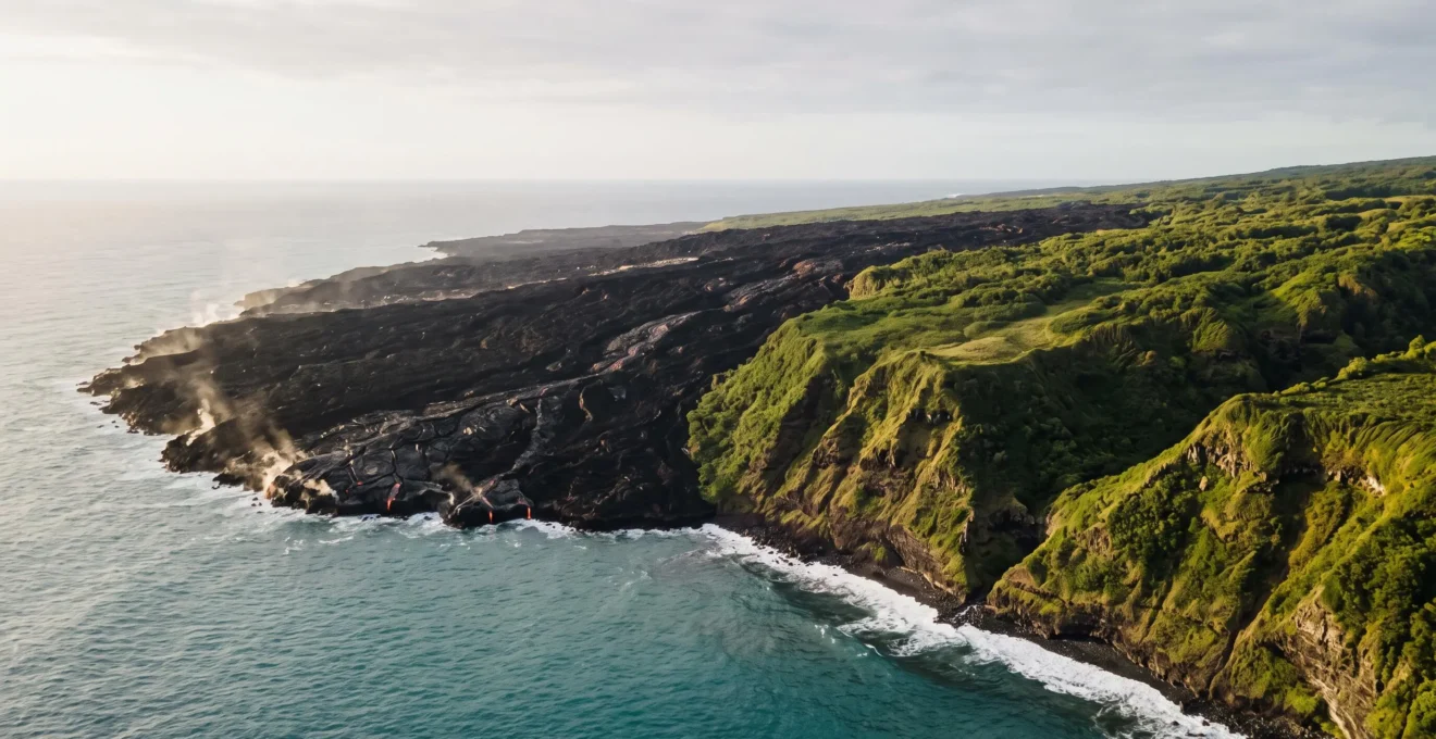
The vast age difference across the Hawaiian Islands is not a random accident but the physical record of a planetary engine at work. A stationary mantle hotspot acts as a volcanic forge, while the immense Pacific Plate drifts slowly over it, carrying away older islands like a conveyor belt. This process creates a geological time-lapse, where each island represents a distinct stage in a multi-million-year lifecycle of creation, life, and erosion, offering a humbling glimpse into the deep, patient rhythms of the Earth.
To stand on the solid ground of a volcanic island is to experience a paradox. The ground beneath our feet feels permanent, an immutable piece of the planet. Yet, this solidity is an illusion, a fleeting moment in a story that unfolds over timescales almost too vast for the human mind to grasp. We tend to see islands as static dots on a map, but the Hawaiian archipelago is something far more profound: it is a slow-motion film reel of planetary creation, a living narrative written in stone and fire over 20 million years.
The common explanation—that the Pacific Plate moves over a stationary “hotspot”—is accurate, but it barely scratches the surface of the full story. It’s the “what” without the “why” or the “how.” It doesn’t capture the awe-inspiring implications of this geological engine. Why does one island become a lush, green paradise while another remains a stark, black rock? How can we learn to read the age of a landscape just by looking at it? And what does this immense, non-human timescale teach us about our own place in the world?
This is not just a story about volcanoes; it is a journey through deep time. By framing the islands not as places, but as different ages in a single, continuous process, we can begin to appreciate the true scale of their formation. We will explore the planetary engine driving this creation, learn to read the clues it leaves behind in the rocks and the lifeforms, and ultimately understand why the 20-million-year age gap isn’t just a number, but the key to unlocking the entire story of the islands.
This guide unpacks the epic story of the Hawaiian archipelago, section by section. We will explore how age dictates everything from soil to life, how to read the landscape like a geologist, and how understanding deep time can change our entire perception of these volcanic giants.
Summary: Why the Oldest Islands Emerged 20 Million Years Before the Youngest
- Why Island Age Determines Vegetation Cover and Soil Development Stages
- How to Date Lava Flows Using Rock Colour and Weathering Patterns
- Hotspot Theory Explained: What Creates Island Chains in Deep Ocean
- How to Visualise Geological Timescales Using Island Age Comparisons
- The Volcanic Hazard Misunderstanding Causing Needless Anxiety in 55% of Tourists
- Why Basalt Formations Reveal Eruption Temperatures Exceeding 1200°C
- Why Volcanic Islands Compress Continental-Scale Diversity Into 2000 Square Kilometres
- Why Black Sand Beaches Signal Volcanic Activity Millions of Years Old
Why Island Age Determines Vegetation Cover and Soil Development Stages
The age of an island is its most fundamental characteristic, a master variable that dictates its destiny. On a geological timescale, rock is not inert; it is the raw material for biology. A young island, recently forged in fire, is a sterile world of black rock. An old island, weathered by millions of years of rain and wind, is a testament to the patient, relentless power of life. The journey from barren lava field to lush rainforest is a direct function of time.
Initially, a new lava flow offers no purchase for life. It is nutrient-poor, non-porous, and lacks the organic matter that forms soil. But over millennia, a slow miracle occurs. Wind and birds carry the first pioneering seeds and spores. Rain begins the long process of breaking down the basalt. Lichens, the first colonists, perform a kind of alchemy, their acids slowly etching the rock and creating the first whispers of soil. This process is incredibly slow, measured not in seasons, but in eons.
As soil develops, more complex plants can take root, creating a positive feedback loop. Their roots break up the rock further, and their decaying matter enriches the soil, paving the way for larger shrubs and eventually, towering trees. This deep, rich soil and dense vegetation are the hallmarks of an older island like Kauaʻi. In this stable environment, life doesn’t just colonize; it evolves. The isolation and unique conditions of the islands drive adaptive radiation, where a single ancestral species can blossom into many new ones. In fact, researchers estimating the pace of adaptive radiation found that unique lineages like the Hawaiian silversword alliance can diversify at a rate of 0.56 new species per million years, a powerful demonstration of evolution’s creative force when given the gift of deep time.
How to Date Lava Flows Using Rock Colour and Weathering Patterns
To the untrained eye, a landscape of volcanic rock can appear monolithic and uniform. But to a geologist, or a deep-time enthusiast, it is a readable text, with each rock’s color, texture, and shape revealing a chapter of its history. Learning to date lava flows visually is about shifting your perception from a human timescale to a geological one, reading the slow, inexorable effects of weathering as a clock.
The youngest lava flows are a deep, glossy black. Fresh from the Earth’s mantle, their surface is often glassy and sharp, having cooled rapidly in the air. Over centuries and millennia, this stark blackness begins to fade. The iron in the basalt starts to oxidize—to rust—imparting a reddish-brown hue to the rock. The longer a rock is exposed to the elements, the more pronounced this reddening becomes. A landscape dominated by red, crumbly rock is broadcasting its ancient age, while one of dark, sharp rock signals a much more recent geological past.
This visual aging process is starkly visible across the islands. On Maui, for instance, a National Park Service geology guide notes that on Maui alone there is an age gap of nearly 750,000 years between the West Maui volcano and the more recent Haleakalā. This difference is not just a number; it’s etched into the very color and shape of the mountains. This progression is a core tenet of understanding the island chain, as experts citing USGS data explain:
The progressive northwesterly drift of the islands from their point of origin over the hot spot is well shown by the ages of the principal lava flows on the various Hawaiian Islands from northwest (oldest) to southeast (youngest).
– Geology.com editorial team, citing USGS data, Plate Tectonics and the Hawaiian Hot Spot
You can train your own eye to spot these clues.
Your Field Guide: Reading a Volcano’s Life Story
- Identify the Deep Submarine Stage: Look for evidence of underwater formation, like the Kamaʻehuakanaloa Seamount, an area still growing beneath the waves off Hawaiʻi Island, representing the very first breath of a new island.
- Spot Emergent Features: Watch for signs of the shallow submarine stage, where erupting magma interacts with seawater, producing dramatic jets of steam and shattered, glassy rock fragments.
- Recognize the Shield-Building Phase: Identify the island’s vigorous youth by the presence of large, active summit calderas and broad, gently sloping flanks, as seen on Mauna Loa and Kīlauea. This is the stage of most rapid growth.
- Note the Postshield Stage: Look for signs of volcanic maturity and decline, where eruption rates slow dramatically. This stage can last for up to a million years after the main shield-building phase ceases, characterized by more sporadic and different types of lava.
- Observe the Final Erosional Stage: See the inevitable effects of deep time in the deeply carved valleys, steep cliffs, and weathered, reddish soils of the oldest islands, where water and wind have long since overtaken fire as the primary shapers of the land.
Hotspot Theory Explained: What Creates Island Chains in Deep Ocean
The elegant, linear arrangement of the Hawaiian Islands is no coincidence. It is the surface expression of a vast planetary engine operating deep within the Earth’s mantle. The concept that elegantly explains this is the hotspot theory, a cornerstone of modern geology. It posits that a stationary plume of intensely hot material rises from the deep mantle, acting like a giant blowtorch aimed at the underside of the Earth’s crust.
This hotspot is the forge. It remains fixed in place, a persistent source of heat and magma for tens of millions of years. Above it, the massive Pacific tectonic plate is in constant, slow-motion drift, moving towards the northwest at roughly the same speed your fingernails grow. As the plate glides over the hotspot, the mantle plume punches through the crust, creating a volcano. This volcano erupts, builds itself up from the seafloor, and eventually emerges from the ocean as an island. But the plate never stops moving. Inevitably, the island is carried away from the hotspot’s magma supply. Its volcanic fires die out, and a new volcano begins to form on the seafloor behind it, directly over the plume. Repeat this process over 80 million years, and you get an immense chain of volcanoes stretching nearly 6,000 km across the Pacific, from Hawaiʻi Island to the submerged Emperor Seamounts near Russia.
This revolutionary idea was first pieced together by a Canadian geophysicist, as the U.S. Geological Survey recounts:
In 1963, J. Tuzo Wilson, the Canadian geophysicist who discovered transform faults, came up with an ingenious idea that became known as the hotspot theory, hypothesizing that the distinctive linear shape of the Hawaiian Island-Emperor Seamounts chain resulted from the Pacific Plate moving over a deep, stationary hotspot in the mantle.
– U.S. Geological Survey, Hotspots: Mantle thermal plumes
To grasp this immense, three-dimensional process, it helps to think in metaphors. Visualizing the thin, brittle crust sliding over a deep, glowing heat source can make the abstract concept tangible.
As this symbolic representation suggests, the process is one of geological unfolding. The hotspot is the persistent narrator, and each island is a word in a sentence being written across the ocean floor, a sentence that can only be read by understanding the immense scale of deep time.
How to Visualise Geological Timescales Using Island Age Comparisons
The greatest challenge in understanding geology is internalizing the sheer scale of its timeline. Human lives are measured in decades; planetary processes are measured in millions of years (mega-annum, or Ma). The Hawaiian Islands offer one of the world’s most elegant tools for visualizing this “deep time.” By laying the islands out in a line, the hotspot has created a physical timeline of the Earth’s recent history.
Simply traveling from the Big Island of Hawaiʻi northwest to Kauaʻi is to travel back in time. You are literally moving from a landscape less than a million years old to one that is over five million years old. This isn’t an abstract concept; it is a tangible experience. The shapes of the mountains, the color of the soil, and the density of the vegetation all change along this path, broadcasting their age. To make this concrete, consider the ages of the principal lava flows that formed the main islands, a direct record of when each island was over the hotspot.
This table, based on USGS data, acts as a geological Rosetta Stone, allowing us to translate location into time.
| Island | Age of principal lava flows (millions of years) |
|---|---|
| Kauaʻi | 5.6 to 3.8 |
| Oʻahu | 3.4 to 2.2 |
| Molokaʻi | 1.8 to 1.3 |
| Maui | 1.3 to 0.8 |
| Hawaiʻi (Big Island) | less than 0.7, still growing |
As this chronology from the USGS shows, the age progression is clear and undeniable. But even this 5-million-year story is just a small sliver of a much larger narrative. To truly induce a sense of humility, consider this: the oceanic crust upon which the oldest island, Kauaʻi, sits is itself far, far older. To grasp the scale, consider that the Pacific Plate crust in this region is around 90 million years old, while the oldest main island is only about 5 million years old. For 85 million years, this patch of seafloor drifted across the empty ocean before it had its fateful encounter with the mantle plume. That unfathomable gap is the true measure of deep time.
The Volcanic Hazard Misunderstanding Causing Needless Anxiety in 55% of Tourists
The word “volcano” often conjures images of sudden, violent destruction, leading to a natural anxiety for those living near or visiting them. However, much of this fear stems from a misunderstanding of geological time and process. While the hazards are real, they are also highly specific and, in the context of Hawaiian-style volcanoes, far less chaotic than many imagine. The anxiety is often born from applying a human-scale fear of the unknown to a planetary-scale process that is, in its own way, quite predictable.
Hawaiian volcanoes are known as “shield volcanoes,” and they behave very differently from the explosive, conical volcanoes found elsewhere in the world. Their lava is typically more fluid, leading to flows rather than cataclysmic explosions. Eruptions are largely confined to specific, well-monitored rift zones and summit calderas. For the vast majority of the islands—the parts that are hundreds of thousands or millions of years past their volcanic prime—the risk of an eruption is zero. The danger is geographically concentrated on the youngest parts of the youngest island. Another hazard, volcanic smog or “vog,” is more widespread. The USGS notes that vog affects the lives of the 138,000 residents and 1.2 million annual visitors on Hawaiʻi Island, but it is a respiratory irritant, not an immediate existential threat for most.
Understanding this context is key. The fear of a surprise eruption on Waikiki Beach is geologically nonsensical. The real experience for most who encounter Hawaiian volcanism is not one of terror, but of profound awe. It is the chance to witness land-building in real-time, a direct connection to the planetary engine. This feeling of wonder, when viewed from a safe and respectful distance, is the dominant emotion.
This image captures the truth of the modern volcanic experience in Hawaiʻi. It’s not about running from a disaster, but about bearing witness to creation. By understanding the island lifecycle, we can replace needless anxiety with a healthy respect and a deep, lasting sense of wonder at the forces that shape our world.
Why Basalt Formations Reveal Eruption Temperatures Exceeding 1200°C
The black rock that forms the Hawaiian Islands is called basalt, and it is a direct messenger from the Earth’s upper mantle. Its very composition and texture are a geological fingerprint, revealing the extreme conditions of its birth. To understand basalt is to understand the intense heat of the planetary engine that drives the hotspot. This is not just any rock; it is solidified fire, a frozen moment from a process that begins deep within the Earth.
When this magma, or lava, finally reaches the surface, geologists explain that basaltic lava exits the vent at a temperature of around 1,200 degrees Celsius (2,200°F). At this incredible temperature, the rock is fluid and glowing, a river of incandescent light. As it flows and cools, it forms different textures—smooth, ropy pāhoehoe or rough, clinkery ʻaʻā—each a clue to how it cooled. But the most dramatic transformation occurs when this immense heat meets the cold of the ocean.
This collision of elements is one of the most powerful creative forces in nature. The thermal shock is instantaneous and absolute. As the ScienceInsights editorial team explains, this is where a unique geological material is born:
The most dramatic fragmentation occurs when hot lava flows directly into cold ocean water, a phenomenon known as littoral explosion, where sudden thermal shock causes the molten rock to shatter instantly into tiny, sand-sized fragments and glass shards called hyaloclastite.
– ScienceInsights editorial team, Why Are Black Sand Beaches Black?
This shattered volcanic glass is the raw material for Hawaiʻi’s famous black sand beaches. It is not eroded from ancient mountains over millennia like continental sand. It is born in a flash of steam and fury, a testament to the incredible temperature difference between the lava and the sea. Every grain of black sand is a tiny piece of a frozen explosion, a reminder of the 1200°C heat from which it came.
Why Volcanic Islands Compress Continental-Scale Diversity Into 2000 Square Kilometres
Volcanic islands are often called “natural laboratories” for evolution, and for good reason. They are isolated worlds where the story of life unfolds in fast-forward. But it is the volcanic nature itself that creates their most remarkable feature: the compression of incredible environmental diversity into a tiny geographical footprint. A single island can contain a range of climates and habitats that would span an entire continent elsewhere.
This is a direct result of the island’s topography. The massive shield volcanoes rise from the sea floor to incredible heights, creating a dramatic elevation gradient. This verticality is the key. As moist ocean air is forced up the slopes of the mountains, it cools, condenses, and releases its water as rain. This creates a “windward” side, which can be a lush, tropical rainforest, and a “leeward” side, which lies in the mountain’s “rain shadow” and can be a dry, arid desert. A journey of a few dozen kilometres can take you from one extreme to the other.
This creates a mosaic of microclimates, from coastal dunes to misty cloud forests, from alpine stone deserts to sub-polar summits. Each niche presents a unique set of challenges and opportunities for life. This environmental pressure, combined with the island’s isolation, is a powerful engine for evolution. It is why a single colonizing species can, over geological time, radiate into a dazzling array of new forms. The Hawaiian silversword alliance is the quintessential example, a group of plants that evolved from a single ancestor to conquer nearly every habitat the islands have to offer.
The Hawaiian silversword alliance is a spectacular example of plant adaptive radiation, with 33 species in three endemic genera that occupy almost all major habitats of the Hawaiian archipelago.
– Blonder et al., Journal of Ecology, Variation and macroevolution in leaf functional traits in the Hawaiian silversword alliance
This single plant lineage has adapted to an astonishing variety of conditions; a single island lineage can be found growing at elevations ranging from less than 100 m to more than 3,900 m. This is the magic of volcanic islands: they build vertical continents, creating a stage where the drama of evolution can play out on a compressed, intensified scale.
Key Takeaways
- Hotspot Conveyor Belt: The Hawaiian island chain is the result of the Pacific tectonic plate moving over a fixed mantle hotspot, creating a linear sequence of islands that get progressively older to the northwest.
- Age is Everything: An island’s age dictates its entire character, from the color and texture of its rocks to the depth of its soil and the complexity of its ecosystem.
- Geological Time is Readable: The islands provide a physical timeline, allowing us to witness the stages of volcanic birth, maturity, and erosion, and understand that even mountains are ephemeral on a planetary scale.
Why Black Sand Beaches Signal Volcanic Activity Millions of Years Old
The image of a black sand beach is iconic, a symbol of Hawaiʻi’s raw, volcanic beauty. It’s easy to assume these beaches are as ancient as the islands themselves, timeless features of the landscape. The truth, however, is far more dynamic and speaks directly to the “geological unfolding” of the islands. Black sand beaches are not a sign of ancient age; they are a signal of geologically recent volcanic activity. They are among the most ephemeral and fragile landscapes in the archipelago.
As we’ve seen, black sand is not the product of slow erosion. It is born in the violent, instantaneous meeting of 1200°C lava and cold ocean water. This means a black sand beach can only form where a lava flow from an active or very recently active volcano has entered the sea. The northwestward drift of the Pacific Plate means that only the southeastern-most islands have been volcanically active in the recent geological past. You find black sand beaches on the Big Island and, to a lesser extent, on Maui, but not on the ancient, deeply weathered shores of Oʻahu or Kauaʻi. Their volcanoes went silent millions of years ago, and any black sand beaches they once had have long since been washed away or buried.
The life of a black sand beach is fleeting. Because the sand is made of glassy, fragmented basalt, it is easily broken down and carried away by the waves. Without a nearby, active lava flow to replenish the supply of new sand, a black sand beach is doomed to disappear. This cycle of creation and destruction is a constant theme in the islands’ story.
Case Study: The Birth and Burial of a Beach
The ephemeral nature of black sand beaches was dramatically illustrated in recent history on Hawaiʻi Island. The 1990 lava flow from Kīlauea completely buried the famous and beloved Kaimū black sand beach in the Puna district, erasing it from the map forever. It was a profound loss. Yet, the geological story continued. The 2018 eruption from the same volcano, in a different location, created a brand new, stunningly beautiful black sand beach at Pohoiki. This powerful example, documented in local geological guides, shows how these features are not permanent fixtures but are tied directly to the coastline’s immediate eruptive history.
To look at a landscape, whether it’s a towering green cliff on Kauaʻi or a fresh black sand beach on the Big Island, is to look at a clock. By understanding the planetary engine of the hotspot and the immense, patient timescale on which it operates, we can learn to read that clock. We can see not just an island, but a moment in a 20-million-year story of fire, water, time, and life. This perspective doesn’t diminish the beauty of the present moment; it deepens it, connecting it to a past that is almost unimaginably deep and a future that will continue to unfold long after we are gone. This is the ultimate lesson of the islands: a profound and humbling sense of our place within the grand, slow, and magnificent story of the Earth.