San Cristóbal de La Laguna’s enduring significance lies not in its preservation alone, but in its role as the primary ‘urban laboratory’ where the unfortified grid was perfected as a reproducible template for colonial expansion in the Americas.
- Its rational urban design predates and directly influenced the famous 1573 Laws of the Indies.
- The city’s plan was conceived as an instrument of peace-time order and cultural administration, not military defence.
Recommendation: View its streetscape as a historical document revealing the origins of modern transatlantic urban planning.
For the discerning urban historian or heritage specialist, the city of San Cristóbal de La Laguna in Tenerife offers more than just picturesque colonial streetscapes. While many travel guides highlight its well-preserved architecture and status as a UNESCO World Heritage site, they often miss the profound story embedded in its very layout. The common understanding is that it’s a “beautiful colonial town,” a relic of a bygone era. This perspective, however, overlooks its primary function in global history: La Laguna was not a relic, but a prototype. It was the first unfortified colonial “city of peace,” an active urban laboratory where a new model of territorial and social order was tested and refined.
The true genius of La Laguna is not merely its grid plan, but the philosophy behind it. Before the Spanish Crown formally codified its urban planning principles in the Laws of the Indies, this city on a remote Atlantic island was already serving as a full-scale experiment. It was here that the concept of a rational, orthogonal layout was perfected not for fortification, but for administration, commerce, and cultural projection. This article moves beyond the surface-level appreciation of its beauty to deconstruct the model. We will explore why this specific grid became the blueprint for hundreds of new cities across Latin America, how to read its historical narrative on the ground, and why its legacy as an intellectual capital is a direct result of its innovative 15th-century design.
This guide will navigate the city’s structure, from the grand principles of its conception to the minute details of its masonry, revealing La Laguna as the foundational chapter in the story of modern transatlantic urbanism.
Contents: Why La Laguna’s Grid Plan Was a Global Game-Changer
- Why Unfortified Colonial Grids Influenced Latin American City Planning for 300 Years
- How to Follow Self-Guided Heritage Trails Using UNESCO Interpretation Signage
- Preserved Colonial Streets vs Modernised Districts: What Development Pressures Threaten Heritage?
- How to Photograph Continuous Colonial Facades Maintaining Period Character
- When Guided Heritage Walks Reveal Hidden Courtyards and Private Interiors
- Why UNESCO and EU Designations Layer Multiple Protection Levels
- Dressed Ashlar vs Rough Rubble Masonry: What Construction Quality Reveals
- Why La Laguna Became the Canaries’ Intellectual Capital for 500 Years
Why Unfortified Colonial Grids Influenced Latin American City Planning for 300 Years
The historical significance of San Cristóbal de La Laguna’s urban plan lies in its role as a reproducible template. Founded in 1496, it was conceived from the outset as a city without defensive walls, a radical departure from the fortified medieval towns of Europe. This was a “city of peace,” designed for administration and civil life, not for siege warfare. Its layout, a grid of straight, wide streets intersecting at right angles, was a physical manifestation of Renaissance ideals of order, rationality, and control. This design wasn’t just aesthetic; it was a powerful tool for organising territory and society in a new colony, making it highly efficient for parcelling land, managing populations, and establishing a clear civic and religious hierarchy.
This model proved so effective that it became the de facto blueprint for Spanish colonisation in the New World. Long before the Laws of the Indies were formally enacted in 1573 to standardise colonial town planning, the La Laguna model was being exported and adapted across the Atlantic. Cities like Santo Domingo, Lima, and Cartagena bear the imprint of this Canarian experiment. It functioned as an “urban laboratory,” demonstrating that a rational, open grid was the ideal framework for imposing a new order. Today, the historic center still preserves around six hundred original buildings from the 16th to 18th centuries, allowing scholars to walk through the original prototype that shaped a continent. The city’s physical form is a living document of this transatlantic transfer of knowledge.
How to Follow Self-Guided Heritage Trails Using UNESCO Interpretation Signage
Experiencing La Laguna’s historical grid is an exercise in active observation. While its geometric purity is evident from a map, understanding its narrative requires walking the streets with intent. The UNESCO interpretation panels, strategically placed throughout the historic centre, are not just informational plaques; they are waypoints in a curated outdoor museum. They provide the vocabulary—architectural terms, historical figures, key dates—needed to decode the urban landscape. A successful self-guided tour uses these signs not as destinations, but as starting points for deeper exploration of the blocks in between.
The grid itself becomes your guide. The long, straight streets create powerful sightlines, terminating in the towers of churches or the facades of notable buildings, constantly orienting you within the master plan. This deliberate visual order was part of the original design’s psychological impact. By following the pattern, you begin to understand the rhythm of the city: the grand public squares giving way to narrower residential streets, the monumental stone of a convent contrasting with the colourful plaster of a merchant’s house. It’s a method that encourages you to see the city not as a collection of individual monuments, but as a cohesive, planned system.
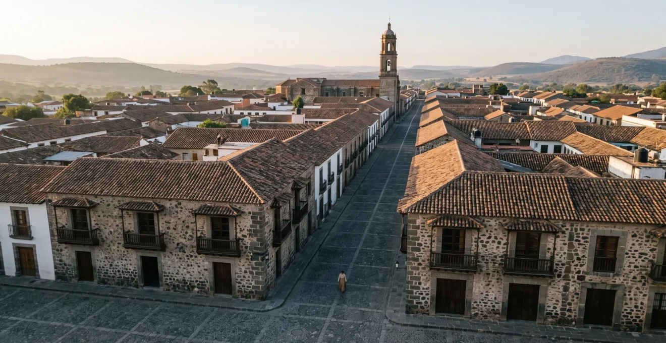
As the image above illustrates, the emptiness of a street can powerfully convey the scale and order of the original plan. The leading lines draw the eye, reinforcing the sense of a rationally organised space that extends methodically toward the horizon. This visual discipline is the essence of the La Laguna model.
Action Plan: Building a Self-Guided Heritage Walk
- Orient Yourself: Start at a major landmark noted on official signage (e.g., the Cathedral or Plaza del Adelantado) to anchor yourself within the grid.
- Observe Between Checkpoints: Use each interpretation panel as a checkpoint, then walk one full block beyond it before consulting the next sign. This forces close observation of the streetscape in between.
- Build a Visual Vocabulary: Note recurring architectural terms on the panels (e.g., balconies, cornerstones, patios) and actively search for additional, unmarked examples nearby.
- Explore the Gaps: Cross-reference the official route with a downloadable walking-tour map to discover side streets not covered by primary signage, often revealing more vernacular architecture.
- Contrast and Conclude: End your walk at a bustling, pedestrianised square to compare the “lived-in” modern city with the historic plan you have just traced.
Preserved Colonial Streets vs Modernised Districts: What Development Pressures Threaten Heritage?
The remarkable preservation of La Laguna’s historic core does not exist in a vacuum. It is under constant pressure from the same forces of modernisation and economic development that affect historic cities worldwide. The primary threat is the delicate balance between conservation and the demands of a living city. One of the most significant pressures comes from tourism itself. The rise of short-term holiday rentals can hollow out residential communities, transforming authentic neighbourhoods into transient tourist zones. This process often leads to gentrification, where in historic centres where short-term rentals are heavily concentrated, research shows prices can rise by more than 30%, pushing out long-term residents and eroding the city’s living culture.
Another, more insidious threat is architectural in nature. As buildings age and require updates to meet modern standards, there is a temptation to resort to “facadism.” This practice preserves the historic outer shell of a building while completely gutting and rebuilding the interior. While it may seem like a reasonable compromise, it often destroys the internal spatial logic, materials, and intangible history of the structure. Heritage conservation researchers have noted this complex dilemma:
Facadism has emerged as a controversial yet increasingly embraced architectural strategy that seeks to preserve the façade of a heritage building while integrating new construction behind it.
– Heritage conservation researchers, Facadism: A Happy Medium to the Dichotomy of Demolition and Conservation
This approach risks turning the city into a film set—historically accurate on the outside, but devoid of its original substance within. Maintaining the integrity of the entire building, not just its public face, is the central challenge for La Laguna’s custodians in the 21st century.
How to Photograph Continuous Colonial Facades Maintaining Period Character
Photographing La Laguna is about capturing more than just pretty buildings; it’s about documenting a historical and aesthetic system. The temptation is to take wide shots of entire streets, but the true character of the city’s design is often found in the details and rhythms of its continuous facades. To maintain a sense of period character, the photographer must act as a curator, consciously excluding modern intrusions like excessive signage, contemporary vehicles, or distracting street furniture. The goal is to isolate the enduring elements of the 16th-18th century design language.
One powerful technique is to focus on rhythm and repetition. Frame a shot along a facade to capture the repeating pattern of windows, doors, and the famous wooden balconies. This emphasizes the modular, ordered nature of the grid’s architecture. Another approach is to shift focus from the macro to the micro. Instead of the whole street, capture the texture of a single element: the hand-carved corner of a wooden balcony, the grain of an old door, or the weathered surface of the volcanic stone used in its construction. These close-ups tell a story of materials, craftsmanship, and the passage of time that a wide shot can miss.
As this macro view shows, the story of La Laguna is written in its very stones. The tool marks, weathering, and texture of the volcanic masonry reveal a tactile history. Capturing these details allows one to photograph not just the city’s form, but its very substance, connecting the grand urban plan to the human hands that built it.
When Guided Heritage Walks Reveal Hidden Courtyards and Private Interiors
The public street grid of La Laguna, with its formal and ordered facades, tells only half the story. The other half lies hidden behind imposing doorways, within the private world of the traditional Canarian courtyard, or patio. These interior spaces are the architectural and social heart of the city’s noble and bourgeois houses. While the street-facing facade presents a public face of order and conformity to the grid, the courtyard reveals a more intimate, private, and often lush world. A guided heritage walk is often the only way for a visitor to gain access to these semi-private realms, which are crucial to understanding the city’s domestic life.
As one guide notes, the city’s identity is defined by this duality between the public and private spheres. The experience is one of contrasts: moving from the sun-baked, stone-paved street into the cool, shaded, and green environment of the patio.
It is dominated by colonial buildings from the 16th to 18th Century, beautiful churches, traditional Canarian houses with open courtyards and wooden balconies, and small squares framed by palm trees.
– World Heritage Site Travel Guide, San Cristobal De La Laguna: UNESCO World Heritage Site Travel Guide
This transition is a key part of the La Laguna experience. The courtyard served multiple functions: it was a source of light and ventilation for the surrounding rooms, a space for gardens, a place for family life away from the public gaze, and a symbol of status. Often surrounded by galleries supported by wooden or stone columns, these patios are where the austere exterior gives way to intricate woodwork and a connection to nature. Discovering them is to discover the city’s soul.
Why UNESCO and EU Designations Layer Multiple Protection Levels
The preservation of a historic city as intact as La Laguna is not accidental; it is the result of a robust and multi-layered legal and institutional framework. The most prominent of these is its designation as a UNESCO World Heritage site, a status that brings both global recognition and a profound responsibility for conservation. The UNESCO World Heritage Committee formally approved the designation in 1999, citing specific criteria related to its unique urban plan. Specifically, La Laguna was recognised under two key criteria: as a unique testimony to a cultural tradition (Criterion ii) and as an outstanding example of a type of building or architectural ensemble which illustrates a significant stage in human history (Criterion iv).
However, UNESCO designation is just one layer. Protection is reinforced by national Spanish laws (Bien de Interés Cultural) and regional Canary Islands government regulations. Furthermore, as part of the European Union, the area can benefit from EU funding for heritage conservation and is subject to European environmental and development directives. This layered protection creates a system of checks and balances. A development project that might be approved at a local level could be challenged based on national heritage law or its potential impact on the “Outstanding Universal Value” defined by UNESCO. This complex web of overlapping jurisdictions ensures that decisions about the city’s future are not made lightly and must consider its global significance, creating a formidable barrier against inappropriate development.
Dressed Ashlar vs Rough Rubble Masonry: What Construction Quality Reveals
A discerning eye can read a city’s social history in its very stones. In La Laguna, the choice of masonry is a powerful narrator of wealth, power, and purpose. The key distinction lies between dressed ashlar and rough rubble masonry. Dressed ashlar refers to large blocks of stone that have been precisely cut into uniform shapes with smooth faces. This type of construction was expensive, labour-intensive, and required skilled masons. Consequently, it was reserved for the city’s most important structures: the facades of churches, the corners of convents, and the grand doorways of the mansions belonging to the conquistador elite and wealthy merchants. Ashlar masonry projected permanence, precision, and order—a perfect material expression of the rational grid plan itself.
In contrast, rough rubble masonry consists of uncut or minimally shaped local stones, often volcanic rock, laid in irregular courses with thick mortar joints. This was a far cheaper, faster, and more functional method of construction, used for the walls of more modest homes, agricultural buildings, and the less visible side walls of grander structures. The visual contrast between these two techniques is stark. By observing where ashlar is used—often just for the quoins (cornerstones) and window frames of a building otherwise made of rubble—you can see a clear display of economic priorities. The quality of construction was a direct statement of social hierarchy, embedding the city’s power structure into its physical fabric for all to see.
Key takeaways
- La Laguna was not just a colonial town but a foundational “urban laboratory” for the Americas.
- Its unfortified grid plan was a tool for peace-time administration, not military defence, setting a new standard.
- Modern pressures like tourism-driven gentrification and “facadism” pose significant threats to its authentic heritage.
Why La Laguna Became the Canaries’ Intellectual Capital for 500 Years
A city’s physical design can profoundly shape its cultural destiny. La Laguna’s well-ordered, safe, and prestigious environment, established from its earliest days as the administrative centre of the Canary Islands, made it a natural magnet for the archipelago’s religious, political, and intellectual elite. The city was not just a place of governance but a centre for learning and theological debate. This concentration of power and intellect laid the groundwork for its long-standing role as the intellectual capital of the Canaries, a status it has maintained for centuries.
This academic tradition was formally institutionalised over time. The establishment of religious orders and seminaries evolved into more formal centres of higher learning. For historians, walking tours reveal layers of history from the conquistador era through religious architecture to academic traditions dating to 1792, with the founding of the Literary University of San Fernando, which would eventually become the modern University of La Laguna. The presence of the university has ensured a continuous intellectual vibrancy in the city, fostering a culture of arts, sciences, and humanities. The city’s original plan, designed for order and civil society, created the perfect container for a culture of knowledge to flourish, a legacy that is just as important as its architectural heritage.
By viewing San Cristóbal de La Laguna through the lens of urban history, its streets, squares, and facades transform from mere scenery into a rich historical text. Understanding its origin as an “urban laboratory” provides the key to unlocking its true significance and appreciating the profound and lasting influence it has had on cities across the globe. The next logical step is to experience this historical document firsthand, equipped with the knowledge to read its every detail.