Tenerife’s radical biodiversity isn’t random; it’s a predictable result of geology, altitude, and ocean physics that you can learn to read like a map.
- Volcanic activity creates a steep altitudinal gradient, stacking radically different climate zones on top of each other.
- The island’s geological age dictates the landscape under your feet, from young, sharp lava fields to ancient, deeply eroded forests.
Recommendation: Stop hiking in single biomes. Learn to traverse these landscape transitions and pack the biodiversity of an entire continent into a single day’s expedition.
For the active nature lover, the search for variety is a constant quest. You seek out destinations that promise more than a single, monotonous landscape. Yet, even the most epic locations often deliver just one dominant flavour—endless forest, sprawling desert, or a uniform coastline. This can leave you feeling like you’ve only sampled a fraction of what nature has to offer. Many travel guides point to Tenerife’s “microclimates” as a solution, a platitude that hints at the truth but reveals nothing of the powerful mechanics at play. They might mention Mount Teide, the trade winds, or the contrast between the wet north and dry south, but they fail to connect the dots.
What if the real adventure wasn’t just to witness this variety, but to understand the forces that forge it? The secret to Tenerife’s astounding diversity lies in a concept I call ecosystem compression. This island is a living laboratory where geological time, a dramatic altitudinal gradient, and immense oceanic forces collide, squeezing the biodiversity of an entire continent into a space of just over 2,000 square kilometres. The true journey is learning to read this landscape-in-motion, transforming a simple hike into an expedition through geological and climatic history.
This guide will move beyond the surface-level observations. We will first explore the powerful mechanisms that concentrate such diversity in one place. Then, we will shift from the ‘why’ to the ‘how,’ providing a framework for you to design your own expeditions, traversing multiple, distinct worlds in a single day. Prepare to see the island not as a collection of sights, but as a dynamic, interconnected system waiting to be explored.
To help you navigate this island of continental diversity, this article breaks down the science and strategy behind exploring Tenerife’s unique landscapes. The following sections will guide you through the forces that create this variety and the techniques to experience it to the fullest.
Summary: Unlocking the Secrets of Tenerife’s Compressed Continent
- Why Volcanic Islands Compress Continental-Scale Diversity Into 2000 Square Kilometres
- How to Design Circular Routes Covering 5 Distinct Landscapes Daily
- Biodiversity Hotspots Explained: What Creates Such Concentrated Variety
- How to Photograph Dramatic Terrain Transitions Without Backtracking
- The Elevation Change Mistake That Exhausts 65% of Unprepared Hikers
- Why Altitude and Ocean Exposure Create 6 Distinct Climate Zones in 50km
- Why Island Age Determines Vegetation Cover and Soil Development Stages
- Why the Oldest Islands Emerged 20 Million Years Before the Youngest
Why Volcanic Islands Compress Continental-Scale Diversity Into 2000 Square Kilometres
The concept of ecosystem compression is the key to understanding Tenerife. Unlike sprawling continents where landscapes transition over hundreds of miles, volcanic islands force radical changes over mere kilometres. The primary engine of this compression is the island’s dramatic topography. A colossal volcanic structure rising from the sea floor creates a powerful vertical gradient, stacking completely different environmental conditions on top of each other on a landmass of just 2,034 km². As one hiker aptly noted, “In one hour you can drive from a sandy beach to a sub-alpine mountain,” which perfectly illustrates how rapidly the island’s terrain shifts.
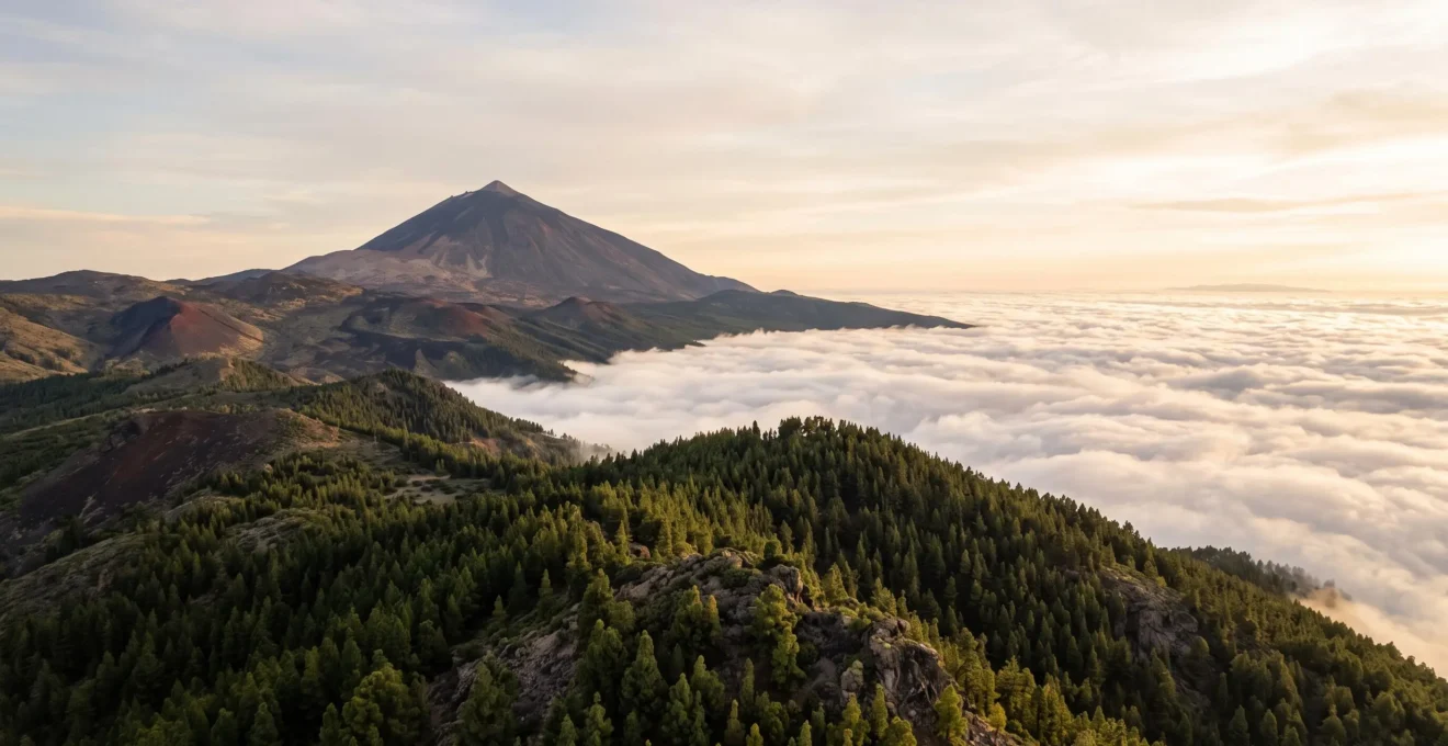
This isn’t just a change in scenery; it’s a fundamental shift in climate, soil, and life. The island acts as a physical barrier to prevailing weather systems, creating starkly different conditions on its windward and leeward sides. This results in sharp, visible boundaries—or ecotones—where one world abruptly ends and another begins. On a single trail, you can walk out of a damp, misty forest and into a sun-scorched, arid lava field.
As the image above demonstrates, these transitions are not subtle. You are literally crossing a threshold between two different climatic realities. The “sea of clouds” (Mar de Nubes) is a perfect example, where moist trade winds are trapped at a certain altitude, bathing the northern slopes in life-giving moisture while leaving the peaks and the southern coast in a rain shadow. It is this intense, topographically-driven separation of environments that allows a hiker to experience a continent’s worth of ecosystems in a single journey.
How to Design Circular Routes Covering 5 Distinct Landscapes Daily
Understanding the theory of ecosystem compression is one thing; experiencing it is another. The challenge for the adventurous hiker is to move beyond linear, single-biome trails and design routes that function as landscape transects, intentionally cutting across multiple zones. The goal is to witness the dramatic shifts from coastal scrubland to laurel forest, pine forest, high-altitude desert, and volcanic peak, ideally within a single day’s expedition. This requires strategic planning, as public transport is often limited and trailheads for different ecosystems can be scattered.
Case Study: The GR131 as a Macro-Transect
The GR131 trail, which crosses Tenerife from the lush forests of La Esperanza in the north to the arid landscapes of Arona in the south, serves as a perfect large-scale example. Over its 67 km, it passes through a staggering variety of environments: dense pine and laurel forests, the stark volcanic caldera of Teide National Park, traditional mountain towns, and finally descends towards coastal views. This single route demonstrates how a linear path can be engineered to intentionally traverse the island’s diverse ecological strata, offering a multi-day masterclass in ecosystem transition.
For day hikes, the principle is the same but on a smaller scale. The key is to use a vehicle to link trailheads. You might start a morning hike in the black pine forests around the Chinyero volcano, then drive a short distance to explore the surreal, lunar-like rock formations of Roques de García in the afternoon. This “hub and spoke” model, basing yourself centrally, allows you to curate a daily diet of maximum landscape variety without the logistical constraints of a long-distance trek.
Action Plan: Logistics for Multi-Ecosystem Hiking
- Secure transport: Rent a car well before your arrival. Public transport primarily serves the main Teide cable car station and will not connect the scattered trailheads you need to access.
- Map your trailheads: Identify and plot key starting points for different ecosystems, such as Roques de García (volcanic), Pico Viejo (summit), Chinyero (pine forest), and the Anaga Rural Park (laurel forest).
- Choose a strategic base: Base yourself near the Teide caldera (e.g., in Vilaflor or near La Orotava) for a few days rather than commuting from the coast. This maximizes trail time and minimizes driving.
- Compare rental options: Don’t book the first car you find. Compare local Canarian suppliers with international brands to find the best vehicle and price for navigating mountain roads.
Biodiversity Hotspots Explained: What Creates Such Concentrated Variety
Tenerife is not just a mosaic of landscapes; it’s a global biodiversity hotspot, a designation earned through its immense number of endemic species—life forms found nowhere else on Earth. This exceptional concentration of unique life is the direct biological consequence of ecosystem compression and geological isolation. When an island is formed, it becomes a blank slate. Over millions of years, species arrive by wind, water, or wing. Isolated from their mainland cousins and facing a huge range of empty ecological niches—from humid cloud forests to sun-baked lava fields—these colonisers undergo rapid evolution, a process known as adaptive radiation.
This evolutionary explosion has resulted in staggering levels of endemism. For example, of the thousands of invertebrate species on the island, an incredible 40% of which are endemic. In the plant kingdom, the results are just as spectacular, with entire genera like the iconic Dragon Tree (Dracaena) and the giant Canary Island spurges (Euphorbia) evolving into forms unique to this archipelago. Each altitudinal zone and microclimate acts as an “island within an island,” fostering its own set of specialized species. The legendary naturalist Alexander von Humboldt recognised this fragility and uniqueness early on, as when he encountered a particular high-altitude flower:
The most fragile and delicate species in Teide National Park.
– Alexander von Humboldt, Cited on Tenerife official tourism guide to the Teide violet
This quote, referring to the Teide violet which grows only above 2,500 metres on the slopes of the volcano, captures the essence of a hotspot. It’s a place of extreme specialization and beauty, but also of profound vulnerability. Exploring Tenerife is therefore not just a physical journey, but a walk through a living museum of evolution.
How to Photograph Dramatic Terrain Transitions Without Backtracking
For the nature photographer, Tenerife presents a unique opportunity and a distinct challenge. The opportunity is the ability to capture wildly different genres of landscape photography—from minimalist desert scenes to lush forest textures—within a single day. The challenge is doing so efficiently, capturing the essence of transition without wasting time and energy backtracking. The key is to think in terms of one-way “photo transects” rather than out-and-back trails.
A successful strategy involves planning routes that are linear or circular, specifically chosen because they cross a major ecotone. Instead of hiking to a viewpoint and returning the same way, you might plan a route that descends from the dry, subalpine zone of Teide National Park into the humid pine forests below. This approach ensures that every step reveals a new composition. The light, colours, and textures change continuously, forcing you to adapt your photographic style on the move. As one photographer-hiker described the experience, the “chill lava loops, surreal lunar landscapes, and full-on summit days demonstrate the extreme range of terrain and light conditions found within a single park visit.”
To execute this, use wide-angle lenses (16-35mm) to capture the grand scale of the transitions, emphasizing the line where one environment meets another. Look for leading lines—a trail, a ridge, a lava flow—that guide the viewer’s eye from one biome to the next within a single frame. Then, switch to a telephoto lens (70-200mm) to compress the landscape, isolating details that highlight the contrast—for instance, a lone, hardy pine set against a backdrop of barren volcanic scree. By planning your route as a narrative of change, you avoid repetition and your portfolio for the day will reflect the island’s true, dynamic character.
The Elevation Change Mistake That Exhausts 65% of Unprepared Hikers
While the dramatic altitudinal gradient is the source of Tenerife’s magic, it is also its greatest challenge. The single biggest mistake unprepared hikers make is underestimating the physiological impact of rapid elevation change. It’s not the distance of the hike that will exhaust you, but the vertical metres gained in thin air. Teide National Park’s main hiking areas lie at a significant altitude, with the park’s altitudinal range from about 2,000 to 3,718 metres. Many visitors arrive from sea level and immediately attempt strenuous activity, a recipe for fatigue, headaches, and even acute mountain sickness (AMS).
The body needs time to acclimatize to lower oxygen levels. A common error is to drive from a coastal resort to the high-altitude trailheads and expect to perform at peak capacity. Hikers often misattribute their sudden exhaustion or breathlessness to a lack of fitness, when it’s simply a normal physiological response to altitude. As one local guide warns, some trails in the park are “properly brutal,” underscoring how quickly the combination of steep terrain and thin air can escalate conditions for those who are not prepared for the vertical challenge.
To avoid this mistake, the solution is simple: acclimatize strategically. Don’t plan your most demanding high-altitude hike for your first day. Spend a day or two doing easier walks at a mid-altitude (1,000-1,800 metres), such as in the pine forests of La Orotava Valley or Vilaflor. Allow your body to adjust. When you do tackle the higher trails, move at a slow, steady pace, drink significantly more water than you would at sea level, and listen to your body. Respecting the altitude is not a sign of weakness; it’s the mark of an experienced and intelligent mountaineer who understands that conquering the vertical is a mental and physiological game, not just a physical one.
Why Altitude and Ocean Exposure Create 6 Distinct Climate Zones in 50km
The “microclimate” platitude vastly undersells the reality of Tenerife’s climate structure. It’s not a random patchwork; it’s a highly organized system of distinct zones sculpted by two primary forces: altitude and exposure to the moisture-laden trade winds. These forces interact with the island’s topography to create predictable, stacked layers of climate, much like the floors of a skyscraper. Driving from the coast to the peak is like travelling from the Sahara to the Alps in under an hour.
The northeast trade winds are the master sculptors. Saturated with Atlantic moisture, they flow towards the island and are forced upwards by the northern mountain slopes. As the air rises, it cools and condenses, forming the famous “Mar de Nubes” or sea of clouds, typically between 600 and 1,800 metres. This process bathes the northern, windward slopes in humidity, creating the perfect conditions for lush laurel and heath forests. Above this cloud layer, the air is dry and clear, creating the high-altitude desert of Teide National Park. This single wind-driven mechanism explains why the north is green and the south is arid. This powerful oceanic influence also means the alpine timberline sits 1,000 metres lower than that of continental mountains of similar latitude, a testament to the sculpting power of the trade winds.
This interaction of altitude and wind creates several distinct zones. The following table, based on recent climate analysis, simplifies this complex reality into three primary bands that a hiker will experience.
| Zone | Approx. Altitude | Climate Character |
|---|---|---|
| Coastal / Beach Zone | 0–400 m | Warm, dry, sunny year-round |
| Mid-altitude Forest Zone | 400–1,500 m | Humid, cloud-covered, lush vegetation |
| High Mountain Zone | Above 2,000 m | Dry climate with extreme temperatures and intense solar radiation |
This predictable layering is what allows you to strategically choose your hiking environment. If it’s cloudy on the coast, you can drive above the clouds into brilliant sunshine in Teide National Park. If the summit is too cold or windy, you can find shelter and warmth in the mid-altitude forests. Understanding this system gives you the power to master the island’s weather.
Why Island Age Determines Vegetation Cover and Soil Development Stages
Walking across Tenerife is like travelling through time. The island wasn’t formed in a single cataclysmic event but built up over millions of years through successive volcanic eruptions. This means different parts of the island are of vastly different ages, and this geological chronology is written directly into the landscape. The age of the ground beneath your feet determines everything: the type of soil, the steepness of the terrain, and the maturity of the vegetation that can grow on it.
Field Notes: Reading Twelve Million Years of History
A field geologist’s account of exploring the island documents this history vividly. They describe how a single day’s exploration can take you from the ancient, deeply eroded shield volcanoes of the Teno and Anaga massifs to the strikingly fresh, barely-weathered lava flows from the 18th-century eruption of Chinyero. This journey through distinct eruptive phases, spanning roughly twelve million years, shows how different parts of the island physically encode different geological ages, offering a tangible connection to the planet’s deep past.
You can see and feel this difference on the trail. The oldest parts of the island, like the Anaga and Teno massifs, which date back 7–9 million years, have had millions of years for erosion to do its work. Here, the terrain is characterized by deep, water-carved ravines (barrancos), rounded hills, and rich, deep soils that support the island’s most ancient and lush laurisilva forests. In contrast, the youngest parts of the island, like the terrain around Mount Teide or the sites of recent eruptions, are sharp, angular, and barren. The “soil” is little more than pulverized black rock (lapilli) or jagged ‘a’ā lava. Here, life is a struggle, and only the most specialized pioneer plants can gain a foothold.
This visual contrast between old and new terrain is one of the most profound experiences on the island. By learning to recognize the signs—the colour and depth of the soil, the shape of the rocks, the type of plants—you are no longer just hiking; you are reading the island’s geological story, a narrative of destruction and creation written over millions of years.
Key takeaways
- Ecosystem Compression: Tenerife’s volcanic nature forces continental-scale biodiversity into a tiny, explorable area through a steep altitudinal gradient.
- Strategic Traverse: The key to experiencing this variety is to plan routes as “landscape transects,” intentionally crossing different climatic and geological zones.
- Read the Landscape: Island age is visible on the trail, from ancient, eroded forests on deep soil to barren, sharp lava fields where only pioneer species survive.
Why the Oldest Islands Emerged 20 Million Years Before the Youngest
To fully appreciate Tenerife’s unique character, it’s helpful to place it within its broader family: the Canary Islands archipelago. This island chain was formed sequentially as the African tectonic plate moved slowly over a stationary “hotspot” in the Earth’s mantle. The easternmost islands, like Fuerteventura and Lanzarote, are the oldest, having emerged some 20 million years ago. They have since drifted away from the hotspot and have been subjected to millions of years of relentless erosion, leaving them as low-lying, rounded, and desert-like landscapes.
In contrast, the westernmost islands, like La Palma and El Hierro, are the youngest and most volcanically active. Tenerife sits in the middle, representing a perfect “middle-aged” stage of island evolution. It is old enough to have developed complex, mature ecosystems in its ancient Anaga and Teno massifs, yet young enough to still possess the towering, active volcanic heart of Mount Teide. This unique combination is the ultimate source of its hyper-diversity.
A Portrait of Age: The View from La Gomera
The neighbouring island of La Gomera offers a glimpse into Tenerife’s potential future. With a geological age of around 12 million years and no recent eruptions, La Gomera is an “elderly” island. Its volcanic heart has gone quiet, and its landscape is now dominated by the forces of water. The interior is dissected by a vast network of deep, dramatic canyons (barrancos) carved over millennia. While it boasts a stunning, ancient laurisilva forest at its core, it lacks the sharp, dramatic volcanic terrain of Teide National Park. This provides a perfect visible contrast, highlighting how Tenerife’s blend of old and new geology is the true engine of its unparalleled variety.
This archipelago context transforms your understanding. You begin to see that you are not just hiking on an island, but on a specific chapter in a much larger story of geological time. Tenerife’s magic lies in its perfect balance—a dynamic equilibrium between the creative forces of volcanism and the patient, sculpting forces of erosion. It’s an island at the peak of its geographical life, and you have the opportunity to explore it.
Now that you can read the island’s deep history in its landscapes, the next step is to apply this knowledge. Transform your next trip from a simple holiday into a true biogeographical expedition.